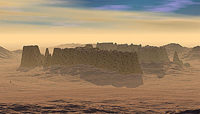
The Time Before Sumeria
The following satellite images are of the oldest sites
that predate those of Sumeria. Although some of these tells are called
cities they really are hardly that. They are the first communities,
small intimate settlements that for most part have a connection with emerging agriculture
but not all.
 Ohalo II
Israel Sea of Galilee
"When
the sea
level fell dramatically in the sea of Galilee ten years ago [1994] the
modern calamity revealed an archaeological treasure: the camp of Stone
Age fishermen and hunters, abandoned nearly 20,000 years ago.
In the last decade, falling water
levels have
allowed Dani Nadel of the University of Haifa in Israel to excavate at
the camp five times. It is emerging as perhaps the best preserved Upper
Paleolithic dwelling site found anywhere in the world.
(http://news.nationalgeographic.com/news/2001/01/0102galilee.html)
The calibrated date is 21,500 BC and the site is similar to the Kebaran culture predating the Natufians. Although this is not a pre-city it is the earliest settlement so far known. Grains were found suggesting the earliest attempt at plant harvesting the forerunner to agriculture. Extremely remarkable as it would be about another nine thousand years before the Natufian culture started farming. As you can see it is presently under water.
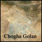 Chogha Golan
Zagros Mountains
"Radiocarbon
dating of the archaeological deposits, some 8 meters in depth, showed
that Chogha Golan had been occupied continuously between about 12,000
and 9,700 years ago or even later. Then, Riehl and her colleagues
traced the use of plants over that entire period of time. According to
their research, the people of Chogha Golan apparently began cultivating
wild barley, wheat, and lentils more than 11,500 years ago, and that
domesticated forms of wheat appeared about 9,800 years ago, nearly as
early as at sites to the west."
(http://www.archaeology.wiki/blog/2013/07/08/farming-developed-independently-in-iran/)
An important site as it is at present the earliest agricultural site in the Zagros Mountains. What makes it exceptional is that it is pre- Neolithic. It would be later during the Neolithic that more communities/tribes turned to farming in the Zagros.
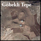
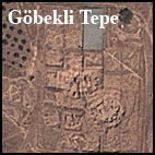 Göbekli
Tepe
Göbekli
Tepe
Eastern
Anatolia
"This
site, currently undergoing excavation by German and Turkish
archaeologists, was erected by hunter-gatherers at perhaps 11,500 B.C.
(This is believed to be before the advent of sedentariness). It is
currently considered the oldest known shrine or temple complex in the
world, and the planet's oldest known example of monumental
architecture."(http://www.realhistoryww.com/world_history/ancient/Anatolia_Turkey.htm)
2015 - Göbekli Tepe as a satellite view no longer displays the stone temples as it is completely covered over by a protective roof. However it is well marked being just northeast of Urfa. The image to the right which is from 2012 shows the structures uncovered.
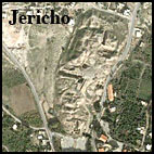 Jericho
East Central Israel
"Jericho is believed to be one of the oldest continuously-inhabited cities in the world, with evidence of settlement dating back to 9000 BC, providing important information about early human habitation in the Near East.[13] The first permanent settlement was built near the Ein as-Sultan spring between 8000 and 7000 BC by an unknown people, and consisted of a number of walls, a religious shrine, and a 23-foot (7.0 m) tower with an internal staircase." (http://en.wikipedia.org/wiki/Jericho)
"The earliest settlement was located at the present-day Tell es-Sultan (or Tell Sultan), a couple of kilometers from the current city. Arabic tell means "mound" -- consecutive layers of habitation built up a mound over time, as is common for ancient settlements in the Middle East and Anatolia. The Neolithic settlements were contemporary with Catalhoyuk and had a similar technology level."
(http://knowledgerush.com/kr/encyclopedia/Jericho/)
"The next people who came to Ein es Sultan are called PPNA (The initials stand for Pre-Pottery Neolithic A). They made their settlement at the spring around 8,000 BC. As the name indicates, they had no pottery. (Though as a well-preserved site at Catal Huyuk, Turkey shows they had wooden vessels).
But the PPNA culture also raised their own domesticated wheat. (The bones of domesticated sheep and goats and the grains of domesticated wheat can be distinguished from the wild varieties easily.)
The PPNA people built circular dome-shaped one-room huts of curved adobe bricks covered over with plastered mud. Similar circular huts are still built by peasants in northeastern Syria and southeastern Turkey. Sites of the PPNA culture are found all over Israel, Jordan, Syria, and northern Iraq and a similar early agricultural village of what was probably a closely related culture is found at Catal Huyuk in south-central Turkey.
PPNA is the first agricultural society known. The spread of PPNA probably went along with the spread of a particular language across the Middle East, so PPNA culture was probably spread by one particular people who drove out or absorbed other peoples."
(http://www.motherbird.com/jerichohst.html)
2016 - Jericho was built by the Natufians the first farmers who abandoned it at about 7,000 BC.
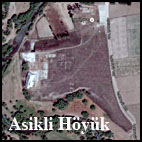 Aşıklı Höyük
Central Anatolia
"Asikli Höyük began at around. 8,000 BC. As in Catal Höyük, the houses were mud brick and entered through the roof. Archaeologists have discovered large numbers of artifacts made from obsidian – black volcanic glass – as well as bone, antler and copper, with an array of blade types. Here too the dead were buried beneath the floor, and one of the skeletons that has been analyzed shows evidence of trepanation (the drilling of a hole in the skull), perhaps for some form of surgery. " (http://www.ancient-wisdom.com/turkeyashikli.htm)
 Çatalhöyük
Southern Central Anatolia
"The ancient settlement was built around 7500 BC, flourished around 7000 BC, and was inhabited for more than two millennia. It was discovered in the early 1960s by British archaeologist James Mellaart from the University of Istanbul." "From 1961 to 1965, excavations at the site produced a huge number of artifacts and ancient structures including a 10-foot-wide wall painting of the town and two peaks, sometimes referred to as the world’s oldest map." To view map image click here.
"The dating of the
volcanic rock indicated an eruption about 8,900 years ago [6900 BC],
which closely overlaps with the time the wall painting was estimated to
have been created. The overlapping timeframes indicate humans in the
region may have witnessed this eruption."
(http://www.sci-news.com/archaeology/science-catalhoyuk-map-mural-volcanic-eruption-01681.html)
2016
- Çatalhöyük
is the correct spelling which was modernized by Turkish authorities.
Latest satellite image.
 Hacilar
Southern West Anatolia
"Hacilar is an early human settlement in southwestern Turkey, 25 km southwest of present day Burdur. It has been dated back 7040 BC at its earliest stage of development. Archaeological remains indicate that the site was abandoned and reoccupied on more than one occasion in its history."
(http://en.allexperts.com/e/h/ha/hacilar.htm)
"Hacilar is another important center in Central Anatolia, near the modern city of Burdur. There is evidence there of agriculture dating back 9,000 years. Archaeologists have found considerable amounts of wheat, barley and lentils in the houses at Hacilar, giving clues to people’s diet and the history of domesticated foods.
Catalhoyuk and Hacilar are also considered two of the earliest clay pottery centers. The existence of pottery is one very important indirect benefits of the sedentary lifestyle created by the ability to produce food year-round and even amass surpluses. Assured of their ability to eat, and able to feed more than just the people who produced food, these stone-age city dwellers had the opportunity and time invent and create." (http://www.crossculturedtraveler.com/archives/JAN2003/Turkey.htm)
2015 - The above image which is new may not be the exact location but it is very close. Directions to the site give it only a general area and a clear dig is not discernible. However, it is east of the river, north of the highway and at about the distance it should be west of Hacilar. Also according to the archaeological notes there should be trenches which seem to be evident in this satellite image. As usual there are always discrepancies which in this case is the size of the tell. It is too small but the notes do not say the entire area has been excavated. The size of Tell Hacilar is about 150 yards in diameter (about 137 meters). Another issue is that the tell may have been reburied as it has in the past.
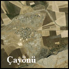
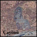 Çayönü
Eastern
Anatolia
"The Çayönü
settlement which is
not far from the city of Diyarbakir has
been unearthed by the expedition teams under the leadership of Cambel,
Braidwood, Mehmet Ozdogan, Wulf Schirmen and it is dated back to
7250-6750 BC. In the middle of the settlement is a center and around it
are monumental, rectangular structures and houses. The foundation of
the structures is stone and above is sun-dried brick. The inhabitants
of Çayönü
are the first farmers
of Anatolia. They raised sheep and
goat, and domesticated dog. The woman figurines among the finds
discovered are the earliest traces of the Mother Goddess cult."
(http://www.turizm.net/turkey/historyofturkeyNeolithic.html)
"The site provided the archaeological world with several 'first's' including animal husbandry, woven cloth, smelted copper Terrazzo (stone pieces pressed into a cement base) floors and several female figurines among the finds representing some of the earliest traces of the Mother Goddess cult in the region. (http://www.ancient-wisdom.com/turkeycayonu.htm)
If you try to find this site using Google Maps or Google Earth you will not be directed to the correct location. In fact both of those locations have differing references as to where Çayönü is located which is too far north for both. The above map is correct and the actual dig is at the top which has a small stream flowing through it and not at the center which is Sesverenpinar.
2015 - Map to right shows a better image of the site due to improved resolution by Google Maps.
 Metsamor
Armenia
"Excavations
have shown strata of occupancy going back to
the Neolithic period (7,000-5,000 BC), but the most outstanding
features of the site were constructed during the early, middle and late
Bronze Ages (5,000-2,000 BC). Inscriptions found within the
excavation go back as far as the Neolithic period, and a sophisticated
pictograph form of writing was developed as early as 2000-1800
BC. The “Metsamor Inscriptions” have a
likeness to
later scripts.
Metallurgy
- The excavation has uncovered a large metal industry,
including a foundry with 2 kinds of blast furnaces (brick and
in-ground). Metal processing at Metsamor was among the most
sophisticated of its kind at that time: the foundry extracted
and
processed high-grade gold, copper, several types of bronze, manganese,
zinc, strychnine, mercury and iron."
ªhttp://www.ancient-wisdom.co.uk/turkeymetsamor.htm)
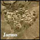 Jarmo
Jarmo
Zagros Mountains,
Eastern Iraq
"Jarmo
is an archaeological site located in northern
Iraq
on the foothills of the Zagros Mountains. For a long time it was known
as the oldest known agricultural community in the world, dating back to
7000 BC. It is also one of the oldest Neolithic village sites to be
excavated. The Jarmo archaeological site was one of the first means of
documentation for the way of life of civilization's first farmers and
herders.
The people reaped their grain with stone sickles, stored their food in stone bowls, and possessed domesticated goats, sheep, and dogs. They also grew emmer and einkorn wheat, barley, and lentils. In addition to their agriculture, they also foraged for wild plants such as the field pea, acorns, pistachio nuts, and wild wheat. The later levels of settlement contained evidence of domesticated pigs and clay pottery. Since many of their tools were made of obsidian from beds 300 miles away, a primitive form of commerce must have existed. Bone tools, especially awls, were abundant from the site. Carefully made bone spoons and beads were also found." (http://www.mnsu.edu/emuseum/archaeology/sites/middle_east/jarmosite.html)
2016 - Correct image of Jarmo after locating latitude and longitude.
 Mehrgarh
Pakistan
"Mehrgarh
is a Neolithic
(7000-3200 BC) site
on the Kachi plain of Balochistan, Pakistan, and one of the earliest
sites with evidence of farming (wheat and barley) and herding (cattle,
sheep and goats) in south Asia. The site is located on the principal
route between what is now Afghanistan and the Indus Valley.
(http://wondersofpakistan.blogspot.com/2009/02/mehrgarh-lost-civilisation_22.html)
A
number of terracotta figurines have been found from
sites in
Mehrgarh dating from the fourth millennium BCE. These represent the
earliest forms of female imagery (formerly believed to represent the
'mother goddess') found in the subcontinent (Elgood, p.331).
(http://www.bukisa.com/articles/144874_archaeological-sites-mehrgarh-an-early-farming-community)
If you go looking for this site you will find it difficult as the Google markers are too far north. This map is correct but even at a higher resolution the detail is not apparent. It could be that this image is too early in the archaeological process or there is not enough detail to see from satellite. It also may have been reburied.
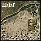
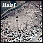 Halaf
Halaf
Northern
Syria
"In the
period 6500–5500 B.C., a farming
society emerged in northern Mesopotamia and Syria which shared a common
culture and produced pottery that is among the finest ever made in the
Near East. This culture is known as Halaf, after
the site of Tell Halaf in northeastern Syria where it was first
identified. The Halaf potters used different sources of clay from their
neighbors and achieved outstanding elaboration and elegance of design
with their superior quality ware. Some of the most beautifully painted
polychrome ceramics were produced toward the end of the Halaf period.
This distinctive pottery has been found from southeastern Turkey to
Iran, but may have its origins in the region of the River Khabur
(modern Syria). How and why it spread so widely is a matter of
continuing debate, although analysis of the clay indicates the
existence of production centers and regional copying. It is possible
that such high-quality pottery was exchanged as a prestige item between
local elites. The Halaf culture also produced a great variety of
amulets and stamp seals of geometric design, as well as a range of
largely female terracotta figurines that often emphasize the sexual
features. Among the best-known Halaf sites are Arpachiyah, Sabi Abyad,
and Yarim Tepe, small agricultural villages with distinctive buildings
known as tholoi. These rounded domed structures, with or without
antechambers, were made of different materials depending on what was
available locally: limestone boulders or mud and straw. The Halaf
culture was eventually absorbed into the so-called Ubaid culture, with
changes in pottery and building styles."
(http://www.metmuseum.org/toah/hd/half/ho_1986.311.1.htm)
2015 - Map to right shows a better image of the site due to improved resolution by Google Maps. If you visit this site via Google Maps the detail will be apparent.
 Hamoukar
Northern
Syria
"Archaeologists
believe they have uncovered the world's oldest city in
a remote part of Syria. Dating back to 6,000BC, the discovery is 2,500
years older than any known site and will prompt a dramatic reappraisal
of ancient history. The huge settlement, called Hamoukar,
is located between the Tigris and Euphrates rivers, an area known
throughout ancient history as northern Mesopotamia. The city spread
over 750 acres and is believed to have been home to up to 25,000 people.
The
discoveries will prompt a re-think of how mankind developed in the
"cradle of civilization" between the two great Middle Eastern rivers,
the Euphrates and the Tigris. It was here that Babylon and Mesopotamia
were established and the oldest known civilization, the Sumerians, were
identified to have lived around 3500BC. But Hamoukar is thought to have
been constructed between 6000BC and 4000BC.
At his
office at the Museum of Raqqa, 300 miles north-east of the
Syrian capital Damascus, Dr Maktash said the discovery would challenge
conventional notions of the development of civilization. "Hamoukar is
at least 1,000 years older than Sumeria," he said. "But we don't know
who the people were who lived at Hamoukar. If they were here first the
big question is: where did the Sumerian civilization come from - from
nothing? It's possible they came from Hamoukar. This will change many
things in our understanding of history." McGuire Gibson, professor of
Chicago University's Oriental Institute, said: "We need to reconsider
our ideas about the beginnings of civilization, pushing the time
further back. This would mean that the development of kingdoms or early
states occurred before writing was
invented." (http://www.crystalinks.com/ud.html)
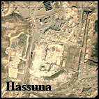 Hassuna
Northern Mesopotamia
"Tel
Hassuna is a Neolithic site found in the Assyrian region, located 22
miles south of Mosul in modern Iraq. In its prime, Tel Hassuna may have
been surrounded by a stream on three sides. It is one of the earliest
Mesopotamian sites, which dates back to late 7th millennium to late 6th
millennium BCE, and is the type site for the Hassuna culture. These
people, who used chipped stone hoes, represent some of the earliest
farmers in northern Mesopotamia. There is evidence for the
domestication of animals such as sheep, goats, and pigs. Hassuna
inhabitants lived in houses made of tauf, or packed mud, surrounding
open courtyards. In the central area of the site, the buildings were
larger in size and seemed to have specific purposes other than housing
inhabitants. Some material remains uncovered from previous excavations
have included ovens used for baking, pots for grain storage possibly
lined with bitumen or gypsum plaster to keep out moisture, and grinding
stones to process grains such as emmer and barely. The pottery found at
the site is called Hassuna pottery and is characterized by red slip on
cream-colored clay. Herring-bone lines decorate the pottery. Stamp
seals, which may have been used for indication of contents or
ownership, usually accompany the pottery. There is evidence of
turquoise in Hassuna, which would have been imported, and is an unusual
find at early sites in Iraq. Other pottery included grey-burnished
pieces which were probably attained through trade. At earlier levels
there is a considerable amount of stone objects, flint, and obsidian.
Beads, pendants, and other small pieces of jewelry have also been
found. Evidence found at Tel Hassuna excavations indicates a reverence
for the afterlife. A dozen pottery-jar infant burials have been found
alongside more jars containing food and drink meant to sustain the
child in the afterlife. Small figurines of a "mother-goddess" form made
from reddish clay have been found. One figurine had a headdress created
for her, molded from a type of green clay."
(http://wikimapia.org/1877943/Tel-Hassuna)
"The
Tell Hassuna people had a neolithic culture in northern Mesopotamia.
Their culture flourished about 6000-5250 B.C. We do not know what these
people called themselves, so Tell Hassuna is a name given as a matter
of convenience. They had no form of writing, so we do not know what
their language was like.
The Tell Hassuna people had a settled
lifestyle. Their communities
varied in size; the maximum population of their towns was about 500.
Most were small villages that covered areas of 2-8 acres. The houses
were rectangular and most had more than one room. Mudbrick formed the
composition of most of the buildings. Residences typically had yards
with walls around them. The residents did much of their cooking in
outdoor ovens. However, there were also some indoor ovens with
chimneys. Floors were plastered and niches in walls were used for
storage.
Farming provided much of the food. The
Tell Hassuna people raised
barley and wheat. They also did a considerable amount of hunting. The
game that they hunted included onagers (wild donkeys) and gazelles. It
is obvious that they did not domesticate donkeys or horses.
Archaeologists have excavated several
sites of this culture. Tell
Hassuna is the largest community. It had some large central buildings
that were divided into small square rooms. These structures had dirt
floors and no hearths. The evidence indicates that they were used for
storage. An archaeological team found 2,400 clay objects that are
thought to have been projectiles propelled by slings. There were also
about 100 large balls made of baked clay; these items may have been
used as weapons.
The inhabitants of the Tell Hassuna towns used stamp seals to make
images on clay. They created an enormous amount of pottery. Alabaster
and terracotta were commonly used for making pottery. Red paint was
used to make linear designs on the pots, bowls, and goblets. Banded
designs were common; the stripes were horizontal on some vessels and
vertical on others.
Many statuettes were created by the Tell Hassuna people. These
figurines were often made of alabaster or terracotta. The small
sculptures frequently represented female figures.
I learned a considerable amount of
information about the Tell Hassuna
culture during my time as a graduate student at the University of
Texas. The Tell Hassuna people were of the stone age, but were quite
advanced for that time frame."
Neal Robbins
(http://www.infohub.com/forums/showthread.php?t=3438 Copyright
© 2009 InfoHub.Inc)
2015 - This map shows the correct site. The old image which had been posted for a number of years was not the site.
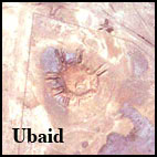 Ubaid
Ubaid
Southern Mesopotamia
"An understanding of the
rise of complex
cultures in southwest Asia should begin with the Ubaid Period which
falls chronologically between the origins of agriculture and the rise
of urbanism. During the Ubaid a new social order was evolving in
southern Mesopotamia and the Susiana Plain (Elam) of SW Iran out of
which emerged complex societies with a centralized state structure.
During the fifth millennium BC Ubaid culture spread northward up the
Tigris-Euphrates drainage as far west as Cilicia and the Amuq. This
foreshadows a similar expansion of what has been interpreted as Uruk
trading colonies or enclaves established to obtain essential raw
materials lacking in the alluvial plain .....PreHistoric Ubaid Culture
(5500-4000 BC)
Tell
(mound) of Ubaid near Ur in southern Iraq has
given its name to the prehistoric culture which represents the earliest
settlement on the alluvial plain of south Mesopotamia. The Ubaid
culture has a long duration beginning before 5000 BC and lasting until
the beginning of the Uruk Period. In the mid 5th millennium BC the
Ubaid culture spread into northern Mesopotamia replacing the Halaf
Culture. The Ubaid culture is characterized by large village
settlements and the appearance of the first temples in Mesopotamia.
Equipment includes a buff or greenish coloured pottery decorated with
geometric designs in brown or black paint; tools such as sickles were
often made of hard fired clay in the south but in the north stone and
sometimes metal were used for tools ....."
(http://ancientneareast.tripod.com/Ubaid_Culture.html)
"In
the
period 5500–4000 B.C., much of Mesopotamia shared a common
culture, called Ubaid after the site where evidence for it was first
found. Characterized by a distinctive type of pottery, this culture
originated on the flat alluvial plains of southern Mesopotamia (ancient
Iraq) around 6200 B.C. Indeed, it was during this period that the first
identifiable villages developed in the region, where people farmed the
land using irrigation and fished the rivers and sea (Persian Gulf).
Thick layers of alluvial silt deposited every spring by the flooding
rivers cover many of these sites. Some villages began to develop into
towns and became focused on monumental buildings, such as at Eridu and
Uruk. The Ubaid culture spread north across Mesopotamia, gradually
replacing the Halaf culture. Ubaid pottery is also found to the south,
along the west coast of the Persian Gulf, perhaps transported there by
fishing expeditions. Baked clay figurines, mainly female, decorated
with painted or appliqué ornament and lizardlike heads, have
been found at a number of Ubaid sites. Simple clay tokens may have been
used for the symbolic representation of commodities, and pendants and
stamp seals may have had a similar symbolism, if not function. During
this period, the repertory of seal designs expands to include snakes,
birds, and animals with humans. There is much continuity between the
Ubaid culture and the succeeding Uruk period, when many of the earlier
traditions were elaborated, particularly in architecture.
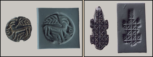
Right: Stamp seal, 6th millennium B.C.; Halaf period Syro/Cilicia
The
impressing of carved stones into clay to seal containers had a long
tradition in Mesopotamia, with the earliest evidence found in Syria
dating to the seventh millennium B.C. During the Ubaid period, the
variety of designs carved on seals expanded from simple geometric forms
to include animals with humans, snakes, and birds. Seals like this one
with deeply carved animal motifs became characteristic of northern
Syria and southeastern Anatolia. It is decorated with a four-legged
horned animal. Above the animal is a leaf shape, possibly a stylized
bird, while two bent lines under its body may represent vegetation or
perhaps snakes."
(http://www.metmuseum.org/toah/hd/ubai/hd_ubai.htm)
"During
the 6th and 5th millennium BC the peoples of Ubaid Mesopotamia and the
Arabian Neolithic met and interacted. This was first realised during
the 1960's and 1970's, when numerous sites were identified in the
Central Gulf region which contained pottery in the Ubaid
style.
These were mostly coastal, and were mainly found in the northeastern
province of Saudi Arabia, though sites were also identified in Bahrain
and Qatar. The majority were small and ephemeral, but a handful were
large, with deep deposits and abundant pottery.
Abdullah Masry studied these sites (Masry 1974), and excavated three of
the most promising ones (Abu Khamis, Dosariyah and Ain Qannas).
Excavations also occurred at smaller Ubaid sites in Bahrain and Qatar
(Roaf 1976; de Cardi 1978). Masry concluded that this part of Arabia
had enjoyed a close and integral relationship with Southern
Mesopotamia. More controversially, he suggested that the Mesopotamian
and Ubaid-related Arabian sites should be regarded as part of the same
social and economic system, and that the origins of Mesopotamian
civilization lie as much in the Arabian Peninsula as in Mesopotamia.
Meanwhile, Joan Oates and her collaborators proved through petrographic
and compositional analysis that the Ubaid-style painted pottery from
the Gulf states originated in Southern Mesopotamia (Oates et al. 1977).
She had a simpler explanation than Masry, suggesting that Ubaid
visitors travelled down the Gulf in search of fish and perhaps pearls,
trading their pottery with local communities along the way."
(http://www.ucl.ac.uk/archaeology/kuwait/backgrnd.htm)
 Tepe Sialk
Central Iran
"After
three phases of excavations, the head of the team Roman Ghirshman
published a book that amazed the academic society of the time.
According to Ghirshman, Sialk was the place where man first used a form
of mortar in construction. It is also the first place where
cloth-weaving, spooling and casting were invented. Evidence suggests
that the site was not only the starting point of Persian civilization
but also the first place where religious thought took form. Further
studies by Iran's Cultural Heritage Organization revealed that Sialk
was as old as 7000 to 9000 years. Settlers first inhabited the region
somewhere around 5500 B.C. - 6000 B.C., drawn to the region due to the
abundant water supply provided by what is known today as Cheshmeh ye
Soleiman (or 'Solomon's Spring')."
(http://www.presstv.ir/detail.aspx?id=37364§ionid=3510304)
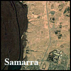 Samarra
Upper Mesopotamia
"Though
the present archaeological site covered by mudbrick ruins is vast, the
site of Samarra was only lightly occupied in ancient times, apart from
the Chalcolithic Samarran Culture (ca 5500–4800 BC)
identified at
the rich site of Tell
Sawwan,
where evidence of irrigation—including flax—
establishes
the presence of a prosperous settled culture with a highly organized
social structure. The culture is primarily known by its finely-made
pottery decorated against dark-fired backgrounds with stylized figures
of animals and birds and geometric designs. This widely-exported type
of pottery, one of the first widespread, relatively uniform pottery
styles in the Ancient Near East, was first recognized at Samarra. The
Samarran Culture was the precursor to the Mesopotamian culture of the
Ubaid period."
(http://en.wikipedia.org/wiki/Samarra)
"Samarra
is now one of the largest
archaeological sites in the world."
(http://www.dur.ac.uk/derek.kennet/samarra.htm)
 Sawwan
Upper
Mesopotamia
"Archaeologists
have found five levels of occupation at Tell es-Sawwan.
The first two are designated as I and II; they are generally thought to
be of the Tell Hassuna culture. These levels have a tripartite building
plan. These tripartite buildings were made around a central room. It
was divided into three parts and a corridor bordered it on each side.
The areas were further subdivided into chambers. Some children's graves
have been discovered in the floors. A number of goods were found with
the remains of the children. These burial items consisted of pottery
and figurines made of alabaster.
Radiocarbon
dating was made from a floor sample of level I; it was
dated to 5506+73 B.C. A similar date (also taken from a floor) was
given for Level II.
In Level
III the architecture has a different pattern. Level IIIA has
T-shaped buildings with fortification features. These include walls,
ramparts, and ditches. In Level IIIB the buildings are converted into
granaries. The radiocarbon dating was made from a floor and is 5349+86
B.C. This level is dated to the Samarra period. [Note - The Samarra
time frame is 5500-500 B.C.] I should mention that not all of the
pottery of Level III is Samarra; some of it is Hassuna. Levels IV and V
are also dated to the Samarra.
A major
change is apparent in Level IV. The fortifications are no
longer used. Level V has been dated to the Halaf period."
Neal Robbins
(http://www.infohub.com/FORUMS/showthread.php?t=3440
Copyright © 2009 InfoHub.Inc)
"Tell
as-Sawwan
was fortified early today in Iraq, 110 km northwest of Badgadista
fairly close to Samarraa. Place is located in northern and central
Mesopotamia frontier rain-growing border, south of.
This
early
settlement was the central Mesopotamia, the Tigris river,
archaeologists running of perhaps about 6300-6100 BC , Whose
inhabitants lived kasteluviljelyllä and store grain. Clay
utensils
and copper machining, cold, perhaps you know. Miniature judging
palvottiin men and women on fertility liiittyen so later than the
Middle East and elsewhere. Tel es-Sawwanin village joined the broader
Samarran culture, which is considered to be the Middle East
sivilisaatiokehityksen pre-operational phase. sawwan located in the
cultural area of the southern border."
(http://fi.wikipedium.org/wiki/Tell_es-Sawwan - Translated)
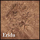 Eridu - The First Known
Sumerian City
Eridu - The First Known
Sumerian City
After the kingship descended from heaven, the kingship
was in Eridu
"I chose
the archeological site Eridu, now known as modern Abu Shah
Rain. Eridu is 196 miles southeast of Baghdad, Iraq. It was the
earliest known city of Sumer (Southern Mesopotamia).There are also an
important group of temples in Eridu (Britannica, 1999)
Eridu was located by the mound called Abu Shayhrayan. This was one of the most important prehistoric urban centers in southern Babylonia. It was built on sand dunes probably in the fifth millennium B.C. It completely showed the sequence of the preliterate Ubaid civilization. Eridu had a long succession of super imposed temples portraying the growth and development of intricate mud brick architecture (Britannica, 1999).
The
apparent continuity of occupation and
religious observance at Eridu provide convincing evidence for the
indigenous origin of Sumerian civilization [emphasis added].
The site was excavated between 1946 and 1949 by the Iraq Antiquities
Department (McDonald) The city continued to be occupied until 600 B.C.
but was less important in historic periods."
(http://www.mnsu.edu/emuseum/archaeology/sites/middle_east/eridu.html)
Eridu is, according to the Sumerians, their first city after the flood. In the King List they document five earlier cities and claim them as their own. Archaeologists, however, would consider these earlier cities as Ubaidian. I consider the cities before the flood and those that came after as Sumerian. As far as I am concerned the Ubaidians are the preflood Sumerians. See page First Legend Introduction for more info.
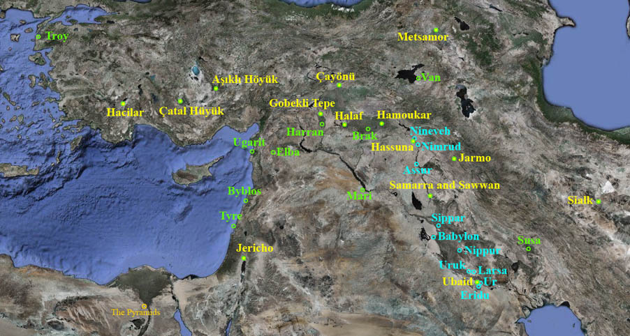
Same
map as on the previous page First Legend Maps
Pre-Sumerian cities in Yellow except for Mehrgarh
which is off the map to the east.
Three famous cities now lost: Dilmun, Akkade and Aratta


